GMDSS Operation: Distress Signals and Communication Channels
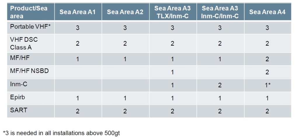
The GMDSS framework designates various Sea Areas, each requiring specific equipment for efficient operation. The Sea Areas and their corresponding ranges and equipment allocations are as follows:
- Area A1: 20 to 50 nautical miles – VHF DSC (Very High Frequency Digital Selective Calling)
- Area A2: 50 to 180 nautical miles (330 km) offshore during daylight hours and 150 nautical miles (280 km) offshore during night time hours. – VHF and MF (Medium Frequency)
- Area A3: Between 70°N and 70°S – VHF, MF, and one INMARSAT system
- Area A4: Above 70°N or S – HF (High Frequency), MF, and VHF

Imagine a massive cargo ship crossing vast oceans, carrying tons of goods or providing crucial services. Months at sea, far from land, what happens if trouble strikes? This is where the Global Maritime Distress and Safety System (GMDSS) steps in, a global lifeline for ships in distress.
Think of GMDSS as a standardized language spoken by radios, satellites, and rescue teams across the world. It ensures ships can send distress calls and receive help, no matter where they are. This system, mandated by the International Maritime Organization (IMO), uses certified equipment to make communication seamless and rescue swift.
But wait, not all ships sail the same waters. Some hug the coast, while others venture deep into open seas. To cater to this, GMDSS defines four sea areas:
Sea Area A1: Coastal cuddlers! Ships here stay close to land, within reach of VHF radio stations. Imagine a walkie-talkie with wider range.
Sea Area A2: Venturing further, these ships rely on both VHF and MF radios for longer-range communication, like a stronger walkie-talkie and a CB radio combined.
An area, excluding Sea Area Al, within the radiotelephone coverage of at least one MF coast station in which continuous DSC (2187.5 kHz) alerting and radiotelephony services are available, as defined by the International Maritime Organization. GMDSS-regulated ships travelling this area must carry a DSC-equipped MF radiotelephone in addition to equipment required for Sea Area A1.
The United States has no Sea Area A2 service. The US Coast Guard 2 MHz infrastructure is closed effective 1 August 2013.
Sea Area A3: Going global? Here, ships use VHF radios and either MF/HF radios or satellite communication (think Inmarsat) for truly worldwide coverage.
An area, excluding sea areas Al and A2, within the coverage of an IMO recognized mobile satellite service in which continuous alerting is available. IMO recognized mobile satellite services currently (2023) include Inmarsat-C and Iridium LT-3100S systems. Ships traveling in this area must carry either an Inmarsat-C or an Iridium LT-3100S ship earth station, or a DSC-equipped HF radiotelephone, in addition to equipment required for an A1 and A2 Area.
Sea Area A3 is defined as the coverage of the IMO-recognized mobile satellite service that the ship is actually carrying, so it would be different for different ships. Recognized satellite services are required to declare their service area, and make that information is made available to its customers. Iridium service area is global. Inmarsat-C service area is shown below.
Sea Area A4: Polar explorers! For the icy regions, ships need robust VHF and MF/HF radios to brave the harsh environment.
The area outside that covered by areas A1, A2 and A3 is called Sea Area A4 Area. Ships traveling these regions must carry a DSC-equipped HF radiotelephone, in addition to equipment required for areas A1 and A2. Note that a ship carrying a ship earth station using an IMO recognized mobile satellite service with global coverage will not have a Sea Area A4. Sea Area A4 for purely geostationary satellite systems will be the polar regions. In the future, if a satellite system with limited regional coverage is recognized by IMO, Sea Area A4 could be a much larger area.
Remember, each area requires specific equipment. This guide helps you understand which radios suit your seafaring needs.

But GMDSS doesn’t stop at radios. Here’s what else ships must carry:
- Portable radios: Like walkie-talkies for onboard emergencies.
- Search and Rescue Transponders (SARTs): Reflect radar signals, making ships easier to find.
- NAVTEX receivers: Get important navigational and safety information.
- Emergency Position Indicating Radio Beacons (EPIRB): Send distress signals even if all else fails.
- INMARSAT stations: Satellite communication for truly global reach.
With GMDSS, large ships have a powerful safety net, ensuring they navigate the world’s oceans with confidence, knowing help is just a call away.
FAQ:
- What is GMDSS?
GMDSS stands for Global Maritime Distress and Safety System. It’s an internationally recognized system that uses terrestrial and satellite communications for ensuring safety and distress alerting in the maritime industry. - What are the GMDSS Sea Areas?
GMDSS divides the world’s oceans into four areas: A1, A2, A3, and A4. These areas are based on proximity to shore and availability of communication services. - What is GMDSS Area A1?
GMDSS Area A1 covers coastal waters up to approximately 20 nautical miles from shore. In this area, VHF radiotelephony coverage is required for distress alerting and communication. - What is GMDSS Area A2?
GMDSS Area A2 extends from the edge of Area A1 to approximately 100 nautical miles from shore. In Area A2, both VHF and MF/HF radiotelephony services are required for distress communication. - What is GMDSS Area A3?
GMDSS Area A3 covers the remaining areas outside of A1 and A2 but within the coverage of an Inmarsat geostationary satellite. It extends to approximately 70 degrees latitude in both hemispheres. - What communication systems are required in GMDSS Area A3?
In GMDSS Area A3, ships are required to have equipment for satellite communication, such as Inmarsat, in addition to the equipment required in A1 and A2 areas. - What is GMDSS Area A4?
GMDSS Area A4 encompasses polar regions not covered by A1, A2, or A3. It extends from approximately 70 degrees latitude in both hemispheres to the poles. - What are the communication requirements in GMDSS Area A4?
In GMDSS Area A4, ships must have equipment capable of providing distress alerting and communication suitable for the harsh conditions of polar regions. - What are the key considerations for vessels operating in GMDSS Area A1?
Vessels operating in GMDSS Area A1 should ensure they have VHF radiotelephony equipment and are familiar with the procedures for distress alerting and communication within this range. - What equipment is mandatory for vessels in GMDSS Areas A1, A2, A3, and A4?
Mandatory equipment includes VHF radiotelephony for A1, VHF and MF/HF radiotelephony for A2, additional satellite communication equipment for A3, and specialized equipment suitable for polar conditions for A4. Compliance with GMDSS regulations is essential for ensuring maritime safety and distress communication effectiveness.


![Onwa KM-8A (BUNDLE) 8-inch Color TFT LCD GPS Chart Plotter with Class B+ AIS Transponder MFD [BUNDLE]](https://seanav.org/wp-content/uploads/2025/04/22-247x296.png)

Pingback: GMDSS Equipment Carriage Requirements for SOLAS Ships
Pingback: Modernized GMDSS: Changes in Radio Surveys for SOLAS Ships in 2024
Thanks for your feedback, we have revised in our post.