
A Comprehensive Guide to the Types of Navigation Equipment on Modern Ships
At Seanav Marine, we take pride in providing you with the most up-to-date information on the types of navigation equipment used on modern ships. With our comprehensive expertise in the maritime industry and our dedication to delivering exceptional content, we aim to outrank other websites and offer you valuable insights into this crucial aspect of ship navigation. In this article, we will delve into the various types of navigation equipment utilized on modern ships, offering you a detailed overview of each category.
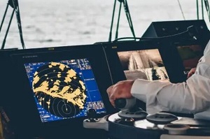
1. X-Band and S-Band Radar
1.1 Purpose
The X-Band and S-Band Radars are essential navigational tools used to detect and track other vessels, land masses, and navigational hazards. They provide accurate information about the ship’s surroundings, including the distance, bearing, and speed of other objects in the vicinity. X-Band Radar operates at a higher frequency and is suitable for short-range applications, while S-Band Radar operates at a lower frequency and provides longer range coverage.
1.2 Requirement
To ensure the effective operation of X-Band and S-Band Radar, ships must have:
- High-quality radar antennas and transceivers
- Properly calibrated radar systems
- Adequate power supply and backup systems
- Skilled personnel trained in radar operation and interpretation
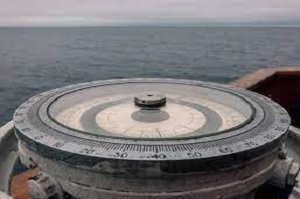
2. Magnetic Compass
2.1 Purpose
The Magnetic Compass is a traditional navigation instrument that provides reliable directional information based on Earth’s magnetic field. It helps determine the ship’s heading, enabling proper course correction and maintaining a steady direction.
2.2 Requirement
To ensure the accuracy and functionality of a Magnetic Compass, it must meet the following requirements:
- Correct calibration and adjustment
- Compensation for magnetic deviations caused by the ship’s structure and equipment
- Adequate lighting for night-time reading
- Regular maintenance and inspection
3. Gyro
3.1 Purpose
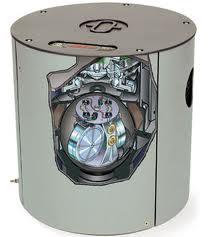
Gyrocompasses are highly reliable navigational instruments that utilize the principles of gyroscope technology to provide accurate heading information unaffected by magnetic interference. They offer precise readings, making them essential for precise navigation and course-keeping.
3.2 Requirement
To ensure the proper functioning of a Gyrocompass, the following requirements should be met:
- Regular calibration and alignment
- Reliable power supply and backup systems
- Periodic maintenance and inspections by trained technicians
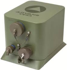
4. Fog Gyro
4.1 Purpose
- Accurate measurement of rotation and angular velocity.
- Provides precise orientation and attitude information.
- Essential for navigation, stabilization, and guidance systems in various industries.
4.2 Requirement
- High sensitivity and resolution for accurate measurements.
- Low noise and drift for reliable and consistent performance.
- Compact and lightweight design for easy integration into different applications.
5. Course Recorder
5.1 Purpose
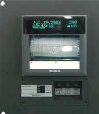
Course Recorders, also known as Track Plotters, are electronic devices that record the ship’s course over time. They provide a visual representation of the vessel’s track, allowing for analysis, reference, and playback of past routes.
5.2 Requirement
To effectively utilize Course Recorders, the following requirements should be considered:
- Installation of a reliable course recording system
- Compatibility with other navigation equipment for data integration
- Adequate storage capacity for recording and archiving tracks
- Regular maintenance and calibration to ensure accuracy
6. Satellite Compass
6.1 Purpose
Satellite Compasses, also known as GPS Compasses, utilize satellite-based positioning systems to provide accurate and reliable heading information. They are an alternative to traditional magnetic or gyro compasses and offer improved precision and resistance to magnetic interference.
6.2 Requirement
To ensure the proper functioning of a Satellite Compass, the following requirements should be met:
- A clear view of the sky for satellite signal reception
- Regular updates of satellite ephemeris data
- Adequate power supply and backup systems
- Periodic calibration and verification of accuracy
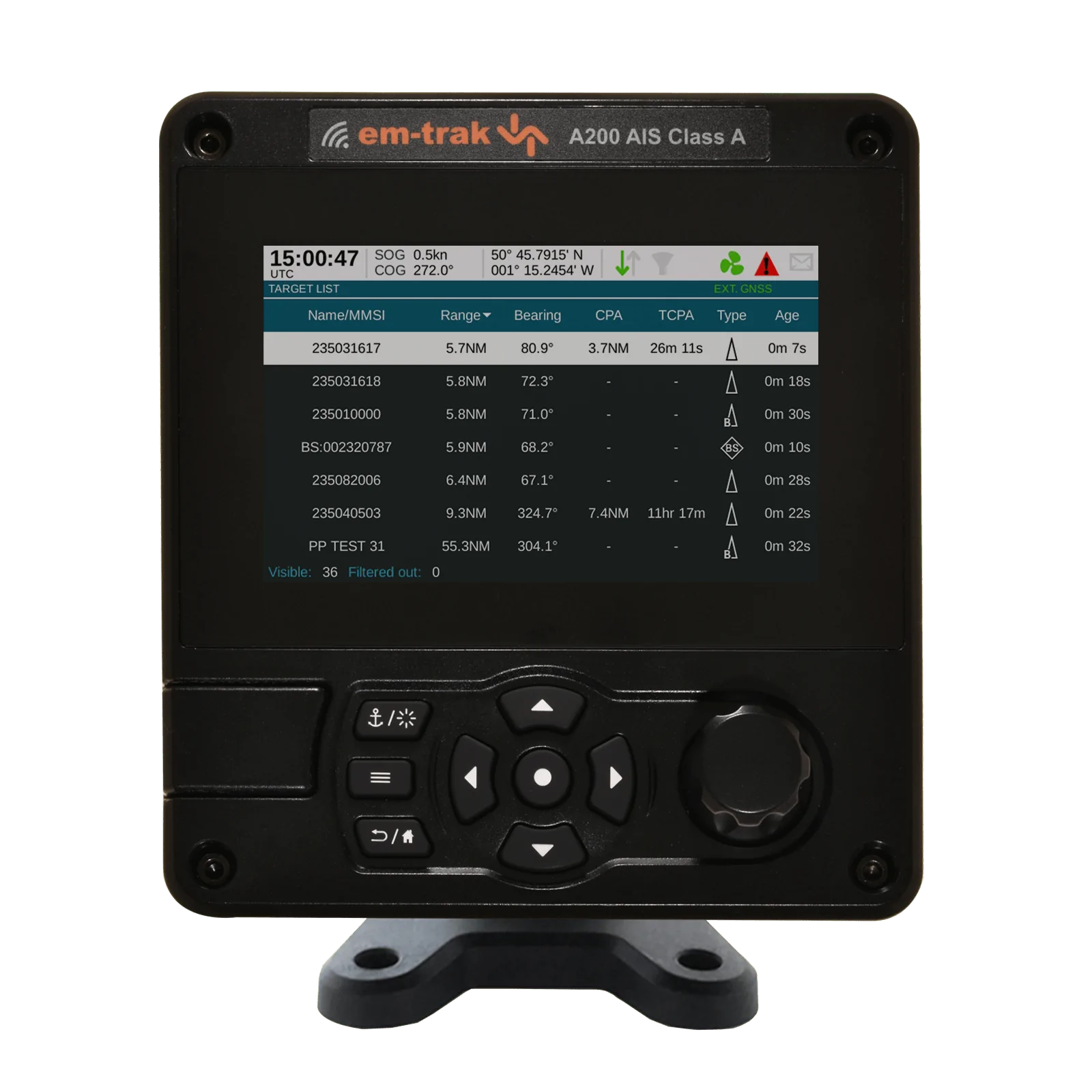
7. AIS (Automatic Identification System)
7.1 Purpose
AIS is an automated tracking system used on ships to exchange vessel information, including identification, position, course, and speed, with other nearby vessels and shore-based stations. It enhances situational awareness, aids collision avoidance, and improves maritime traffic management.
7.2 Requirement
To utilize AIS effectively, ships must meet the following requirements:
- Installation of AIS transponders or receivers
- Proper integration with ship’s navigation system
- Compliance with international regulations and reporting standards
- Regular maintenance and software updates
8. Autopilot
8.1 Purpose
Autopilots are devices that automatically steer the ship based on pre-set parameters or input from navigational systems. They reduce the workload on the helmsman, maintain the desired course, and allow for precise navigation.
8.2 Requirement
To ensure the effectiveness of an Autopilot system, the following requirements should be considered:
- Compatibility with the ship’s steering mechanism
- Integration with navigation systems for course input
- Reliability and accuracy in maintaining the desired course
- Regular maintenance and calibration to ensure proper functioning
9. GPS/DGPS
9.1 Purpose
GPS (Global Positioning System) and DGPS (Differential GPS) are satellite-based positioning systems used to determine the ship’s precise location and provide accurate navigational data. They rely on a network of satellites to provide real-time positioning information.
9.2 Requirement
To effectively utilize GPS/DGPS, ships should meet the following requirements:
- Installation of GPS/DGPS receivers
- Access to a clear view of the sky for satellite signal reception
- Regular updates of GPS/DGPS data and software
- Adequate power supply and backup systems for uninterrupted operation
10. Echosounder
10.1 Purpose
Echosounders, also known as Depth Sounders, are used to measure water depth beneath the ship. They utilize sound waves and their reflection to provide accurate depth readings, aiding in safe navigation, and avoiding shallow waters or underwater obstructions.
10.2 Requirement
To ensure accurate depth measurements, ships must meet the following requirements:
- Installation of a reliable echosounder system
- Proper calibration and adjustment for accurate readings
- Adequate power supply and backup systems
- Regular maintenance and inspection
11. Sonars/Fishfinder
11.1 Purpose
Sonars and Fishfinders are essential marine equipment used for underwater detection and mapping. Sonars are commonly used for detecting underwater objects, measuring water depth, and creating detailed images of the seafloor. Fishfinders, on the other hand, are specialized sonar systems used primarily for locating and tracking fish schools.
11.2 Requirement
To effectively utilize Sonars and Fishfinders, the following requirements should be met:
- Installation of high-quality sonar systems with appropriate frequencies and transducers
- Adequate power supply and signal processing capabilities
- Regular calibration and maintenance to ensure accurate readings
- Skilled operators trained in sonar interpretation and analysis
12. Speed Log
12.1 Purpose
Speed Logs, also known as Doppler Logs, are instruments used to measure the speed of a vessel through water. They provide crucial information for navigation, fuel consumption calculations, and overall voyage planning.
12.2 Requirement
To ensure accurate speed measurements, ships should fulfill the following requirements:
- Installation of a reliable and calibrated speed log system
- Regular maintenance and calibration to compensate for fouling or damage
- Integration with other navigation systems for data correlation
- Adequate power supply and backup systems
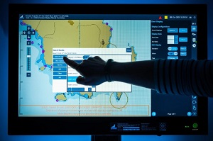
13. ECDIS (Electronic Chart Display and Information System)
13.1 Purpose
ECDIS is a computer-based navigation system that integrates electronic navigational charts (ENCs) and additional navigational information. It provides an interactive display of the ship’s position, navigational data, and electronic charts, aiding in safe route planning and real-time navigation.
13.2 Requirement
To effectively utilize ECDIS, ships must meet the following requirements:
- Installation of approved ECDIS hardware and software
- Access to up-to-date electronic charts and relevant data updates
- Proper integration with other navigation systems for data exchange
- Crew training and proficiency in ECDIS operation and interpretation
14. Wind Sensor
14.1 Purpose
A Wind Sensor, also known as an Anemometer, is a device used to measure the speed and direction of wind. It provides crucial information for navigation, ship stability, and the safety of onboard operations. The wind data helps the crew make informed decisions regarding sail setting, course planning, and weather conditions.
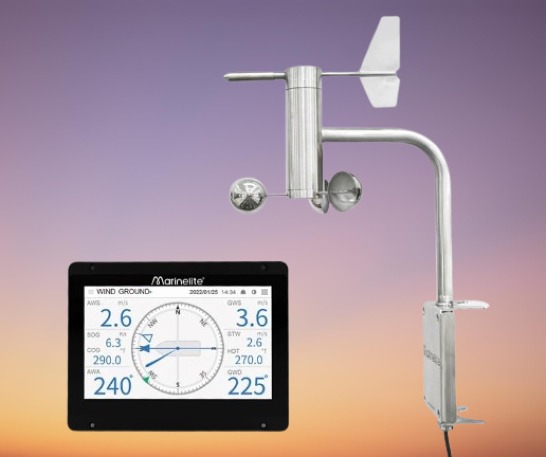
14.2 Requirement
To effectively utilize a Wind Sensor, ships must meet the following requirements:
- Installation of a reliable and accurate wind sensor
- Proper positioning for unobstructed wind measurement
- Integration with navigation and weather systems for data correlation
- Regular maintenance and calibration to ensure accurate readings
15. BNWAS (Bridge Navigational Watch Alarm System)
15.1 Purpose
A BNWAS, or Bridge Navigational Watch Alarm System, is a safety device that monitors the bridge watchkeeper’s presence and attentiveness. It helps prevent accidents caused by watchkeeper fatigue, distraction, or incapacitation by issuing alarms and ensuring a continuous watch is maintained.
15.2 Requirement
To ensure effective implementation of a BNWAS, ships must meet the following requirements:
- Installation of a certified BNWAS system
- Integration with bridge systems and alarms
- Configuration to comply with international regulations
- Regular maintenance and testing to ensure proper functionality
16. Conning Displays
16.1 Purpose
Conning Displays provide the ship’s navigational officers with essential information to make informed decisions during maneuvering and docking operations. They present real-time data, such as heading, speed, rudder angle, and position, in a clear and easily understandable format.
16.2 Requirement
To effectively utilize Conning Displays, ships should meet the following requirements:
- Installation of reliable and user-friendly conning displays
- Integration with navigation systems and sensors for data acquisition
- Adequate display size and positioning for easy visibility
- Regular maintenance and software updates
17. Current Meters
17.1 Purpose
Current Meters, or Flowmeters, are instruments used to measure the speed and direction of ocean currents. They provide valuable information for route planning, assessing tidal conditions, and optimizing fuel efficiency.
17.2 Requirement
To ensure accurate current measurements, ships should fulfill the following requirements:
- Installation of reliable and calibrated current meter equipment
- Proper positioning and deployment of the current meter to minimize interference
- Adequate power supply and data logging capabilities
- Regular maintenance and calibration to maintain accuracy
18. Integrated Bridge System
18.1 Purpose
An Integrated Bridge System (IBS) is a comprehensive system that combines various navigation and communication equipment into a single interface. It provides a centralized control and monitoring system for efficient and safe vessel operations.
18.2 Requirement
To effectively utilize an Integrated Bridge System, ships must meet the following requirements:
- Installation of compatible and certified equipment for integration
- User-friendly interface and display for easy operation
- Redundancy and backup systems for reliable performance
- Regular software updates and maintenance to ensure system stability
19. Multifunction Displays
19.1 Purpose
Multifunction Displays (MFDs) are versatile devices that consolidate and present multiple types of information on a single screen. They provide real-time data, including navigation charts, radar images, sonar readings, and engine parameters, enhancing situational awareness for the crew.
19.2 Requirement
To effectively utilize Multifunction Displays, ships should meet the following requirements:
- Installation of high-resolution and sunlight-readable displays
- Compatibility with various data sources and communication protocols
- Integration with other navigation and communication systems
- Regular software updates and calibration for accurate data representation
20. NAVTEX (Navigational Telex)
20.1 Purpose
NAVTEX is an automated system that provides navigational and meteorological warnings, as well as other safety-related information, to ships within range of a coastal station. It aids in timely receipt of critical information to ensure safe navigation.
20.2 Requirement
To effectively utilize NAVTEX, ships must meet the following requirements:
- Installation of NAVTEX receivers compatible with the designated frequency range
- Proper antenna positioning for reliable signal reception
- Regular monitoring and maintenance of the system
- Compliance with regulations regarding the storage and disposal of received messages
21. GPS Chart Plotters
21.1 Purpose
GPS Chart Plotters are navigation devices that combine Global Positioning System (GPS) technology with electronic charts. They provide real-time positioning information, route planning, and visual representation of the vessel’s track on electronic charts.
21.2 Requirement
To effectively utilize GPS Chart Plotters, ships should meet the following requirements:
- Installation of GPS receivers and chart plotter software
- Access to up-to-date electronic charts and updates
- Integration with other navigational sensors and systems
- Regular software updates and maintenance for optimal performance
22. Steering System
22.1 Purpose
The steering system is responsible for controlling the direction of the vessel. It allows for precise and responsive maneuvering, ensuring safe navigation and course-keeping.
22.2 Requirement
To ensure an efficient steering system, ships must meet the following requirements:
- Installation of a reliable and robust steering mechanism
- Compatibility with the vessel’s size, design, and propulsion system
- Regular maintenance and inspection of steering components
- Adequate backup systems in case of steering failure
23. VDR (Voyage Data Recorder) & S-VDR (Simplified Voyage Data Recorder)
23.1 Purpose
Voyage Data Recorders (VDRs) and Simplified Voyage Data Recorders (S-VDRs) are crucial devices that capture and store essential data for ship navigation and audio communications. They act as digital “black boxes,” recording navigational details like position, speed, and heading, along with audio recordings from the vessel’s bridge and other critical areas. Their purpose is to provide reliable and accurate records of events leading to accidents or incidents. This recorded data is invaluable for accident investigation authorities, ship operators, and regulatory bodies in identifying causes, improving safety practices, and preventing similar incidents. VDRs and S-VDRs are designed to endure extreme conditions, ensuring data integrity, and compliance with regulations set by the International Maritime Organization (IMO) guarantees the availability and accessibility of recorded data for investigations.
23.2 Requirement
To effectively utilize VDRs and S-VDRs, ships must meet the following requirements:
- Installation of a certified and compliant VDR or S-VDR system
- Proper placement of microphones and cameras for audio and visual recording
- Reliable power supply and backup systems to ensure continuous recording
- Regular maintenance, data extraction, and storage for future analysis
24. Weather Fax
24.1 Purpose
Weather Fax is a system that receives and decodes weather charts, satellite images, and other meteorological information. It provides vital weather updates to aid in voyage planning, route optimization, and weather monitoring while at sea.
24.2 Requirement
To effectively utilize Weather Fax, ships should meet the following requirements:
- Installation of a weather fax receiver and compatible software
- Adequate antenna positioning for clear signal reception
- Regular monitoring of weather frequencies and channels
- Proper storage and cataloging of received weather charts for reference
Latest Products
8-inch Color TFT LCD GPS Chart Plotter with EchoSounder, AIS Transponder, and Radar MFD (5-in-1)
8-inch GPS Chart Plotter with AIS and Radar
Onwa KM-8A (BUNDLE) 8-inch Color TFT LCD GPS Chart Plotter with Class B+ AIS Transponder MFD [BUNDLE]
Onwa KM-8C 8-inch Color TFT LCD GPS Chart Plotter with EchoSounder MFD